Thursday, December 12, 2013

RonnieAdventure #0078 - Zion National Park, Part 2, Washington County, Utah

I had so much fun looking at all of my file pictures from Zion, I decided to continue the last RonnieAdventure for another week. Although most people think of Zion as park full of mountain peaks, canyons, streams and waterfalls, there are also Aspen trees in the "high country."


Pine Creek is popular for canyoneering because the trail starts at the edge of a highway and ends a few miles down the road at the same highway. The only problem with the trail is that at one point you have to rappel into a pool of cold water and then swim to the other side. However, there are some dry sections of the canyon where you can see the sun and get warmed up.


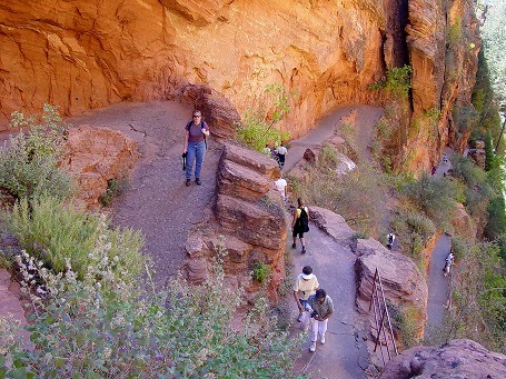
The trip to Canyon Arch is a great hike because it incorporates a number of different aspects found in Zion, all in a very short distance. The first part of the trail is well maintained and there are even steps cut in the rock to make the assent easier. The trail also goes close to Weeping Rock, which is a large alcove with dripping spring and a lot of hanging plants and moss. The trail narrows as you get higher in the canyon and there are chains attached to the canyon walls for those that would like a little extra security when crossing the narrow ledges. The arch itself is very hard to photograph, because it is in a canyon and there is no way to take a picture with nice blue sky in the background. However, it is possible to find sunflowers and blue sky in the open areas.


"Subway" is probably the most popular hike in Zion, so it is very difficult to get a hiking permit to enter the canyon. However, the wait is worth it because the scenery is fantastic,


 (Restaurant located outside of the park - If anyone knows what a "New York Style Chinese Buffet" is, please let me know. Thanks!)


Saturday, December 7, 2013

RonnieAdventure #0077 - Zion National Park, Part 1, Washington County, Utah

First impressions can sometimes be deceiving. The first time I visited Zion National Park was in the middle of the summer -- the temperature was over 90 degrees Fahrenheit (with no breeze), the main road up the canyon was overly crowed with bumper-to-bumper traffic, and there was no place to park a vehicle at any of the trailheads. Talk about a disappointment! I could not believe they made this place a National Park, so I did not return for over 25 years.

When I finally returned it was in September and it was a totally different experience-  the weather was ideal, the colors were beautiful, there were no privately owned vehicles on the main canyon road, a new visitors center had been constructed that incorporated a large parking lot for private vehicles, and there was an efficient shuttle system that carried people up and down the canyon - for FREE! Thus, over the past decade Zion has become one of my favorite National Parks in the Southwest and we have visited there often.

Our recent trip in November, which is later than we typically visit the Park, most of the leaves had fallen from the deciduous trees located along the Virgin River; however, we did find a few spots that still had some beautiful colors. There were only a few tourist in the Park, so a number of animals were feeding close to the road. I almost missed a picture of a nice buck that walked by me before I could get my camera out of the case and take a picture.


Since I didn't take many pictures on this trip, I'm including some file pictures from other Zion Visits. In May of 2011, we had an exciting canyoneering adventure in Birch Hollow. Even though the water was a little on the cold side, it was one of those trips that you never forget.


Angles Landing is a great hike, but not advised if you are afraid of heights. The last part of the trail is very narrow and you have to hold on to a chain as you cross a narrow ridge and then ascend a fairly steep rock face. You also want to start earl in the morning when it is cooler and the trail is in the shade.


Most people that hike in "The Narrows" do a bottom-up day hike and just start from the road at the bottom of the canyon. It is not easy walking against the water current when you are going upstream, so day hikers typically only go a short distance up the canyon and then return back down the river to the road. However, for the more adventuresome, you can do a top-down trip and start at Chamberlain's Ranch and then hike all 16 miles down the canyon in one day (or if you are lucky, you can get one of the few overnight permits). This trip is not recommended if you are out-of-shape or not accustomed to hiking in water over slippery rocks. (All of my pictures were taken before the confluence with Deep Creek and Kolob Creek. The water was too deep and the current was too swift after that point, so I kept my camera in a waterproof container for the rest of the trip.)