It's that time of year again when the desert is calling, so we headed for the Mojave National Preserve in eastern California. Since we had never been across the east side of the Preserve, we decided to follow the old railroad grade from Ivanpah Valley to Goffs.
In 1893 the Nevada Southern Railway was extended north from Goffs to the New York Mountains for the purpose of hauling ore, but soon went bankrupt. The railroad was reorganized in 1895 as the California Eastern Railway and in 1902 the railroad was extended north to the Ivanpah Valley where it was acquired by the Santa Fe Railroad. The mines soon played out and the railroad was abandoned in 1923. After the tracks were removed, the railroad grade became an "unimproved road" across the Mojave Desert. (The only problem with following an "unimproved road" is that the definition of "unimproved" is not really very well defined and the definition changes with the season of the year. For this trip, "unimproved" was a trail covered with nasty rocks where it crossed the New York Mountains and then turned into a nice sand wash for the remainder of the trip. I like sand washes, but I really hate bouncing over rocks - they tend to eat tires very quickly.)
A monument and a section of original rail have now been placed where the railroad grade crosses the Old Mojave Road (Old Government Road). For those that like desert camping, the Mojave Desert Outpost (campground) is located about 0.25 miles south of the monument and is equipped with pit toilets.
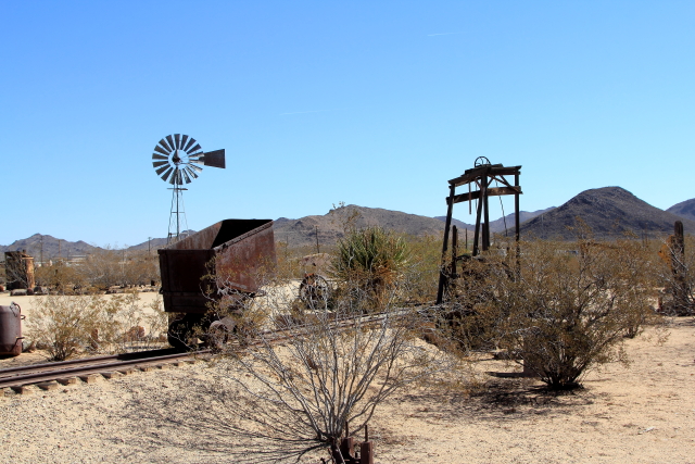
And, there are some interesting yard art displays about another 0.25 miles south of the Mojave Desert Outpost.
Goffs was founded in 1893 to support the railroads, but it also became a major stop on the Old Trails Road, which later became known as U.S. Highway 66 ("Route 66"). In 1936, Route 66 was realigned and bypassed Goffs, but during WW II Goffs had a resurgence because it was in the midst of the Desert Training Center Army Camp with more than 10,000 soldiers stationed here at various times. Today, Goffs is a small community located next to a very busy railroad line and an interesting open-air museum.
The community of Essex was founded in 1915 when a motorist had a flat tire and discovered that there was not a garage for miles in any direction. The town is located along Route 66 ("The Mother Road") and in later years became a popular stopping spot because travelers were provided free water from a well installed by the Automobile Club of Southern California.
In later years Essex became famous when Johnny Carson discovered that the community was too far from any transmitter to receive a television signal, so he invited the entire community of Essex (about 50 people at the time) to be on his show March 25, 1977. Someone that watched the television show felt sorry for the people living in Essex and donated a television transmitter to the community so that they could watch television. Essex now has a population of 8-10 people and is on the verge of becoming a ghost town. But, they have television!
The remains of WW II Camp Essex Army Airfield are still visible just northeast of town. When active, there were two parallel runways and twelve "handstands" where aircraft could be parked. The site is best viewed from the air.
 |
| Google Photograph |
About 15 miles southwest of Essex is a roadside display that marks the location of the WW II Desert Training Center/California-Arizona Maneuver Area that was established in 1942 by General George S. Patton. Roads, building locations, and maneuver areas are still visible in the desert sand. Also visible are the remains of four covered picnic table areas that were part of a rest stop built at this location in the 1950s.
Between 4 and 4.5 miles east of Amboy, there are two Oriental lions located just off the highway right-of-way that apparently serve as property line boundary markers. The lions just really look out-of-place in the Mojave Desert!
Amboy was once a major stop when traveling on Route 66 and is the location of the famous Roy's Motel and Cafe, a major Route 66 landmark. Unfortunately, Roy's has gone through some hard times over the past few years and now I could not even get a chocolate milk shake in the Cafe (bottled beverages only)!
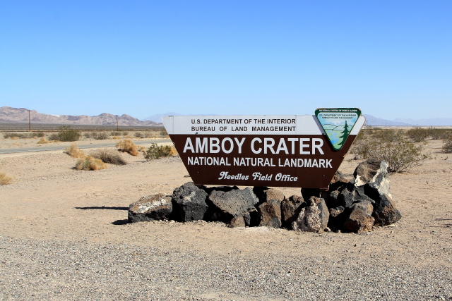
Amboy crater is a relatively young (in geological time) cinder cone that last erupted about 10,000 years ago. There are various hiking trails in the area, including a trail to the top of the crater.
Several years ago some high school students placed some old tires in the center of the cone and then doused the tires with gasoline and set them on fire. When black smoke started coming out of the crater, people in the area panicked. Authorities did not think the stunt was funny!
Just south of Amboy, on Bristol Dry Lake, there are long lines of small cones in every direction, We finally found a BLM brochure explaining that the cones are part of two large active salt mines and "much of the sodium and sodium chloride which is used in high school chemistry classes comes from these two private companies." The dry lake is about 14 miles long and 12 miles wide, containing an estimated 60 million tons of materials in reserve; so the mines will probably be active for a number of years.