|
| File Picture |
Now that US Highway 93 is being developed into Interstate 11 between Las Vegas and Phoenix, the four main hiking trails south of Hoover Dam are being realigned to have a common trailhead ("White Rock Canyon Trailhead") that start from a large asphalt paved parking lot on the east side of the highway. The nice thing is that for the three trails leading to the west you no longer have to risk your life crossing the highway because you can now walk under two new bridges that cross White Rock Wash.


Since it was a beautiful spring day for a hike, we decided to take an alternate route to Liberty Bell Arch by deviating from the new trail after we crossed under the bridges and followed an old little used trail that went north and connected into the "good old days" original Liberty Bell Arch trail. Unfortunately, the side trip added about a mile to our trip, and it was all uphill to the old trail; but when you are retired you do not have to hurry. Besides, when you are with good company you can stop and visit along the way and reminisce about the "good old days." After reaching the top of the hill, we followed the old trail along the ridgeline and then went back down the hill to join the current Liberty Bell Arch Trail. Because of the rugged terrain in this area, it really reminds me of hiking in the Arizona Superstition Wilderness Area.


 |
| File Picture |
 |
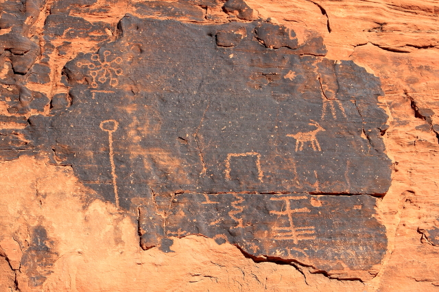
| File Picture
At the junction of the old and new trails, there is an old hand-made road that leads up the hill to a World War II Manganese Mine. You have to be careful walking around the hill because there are numerous vertical shafts that are not fenced leading downward to an adit (horizontal mine shaft) that exits into a wash on the north side of the hill. Although the vertical shafts provide light in the adit, no mine shaft should ever be entered as they may be unstable and can cave in at any time. There are a lot of old buckets, cables, mining equipment and "junk" scattered about the area, but everything at the mine is protected by law and cannot legally be removed from the site.
|


From the old mine the trail goes down the hill, through a nice valley and then up another hill to the arch. The best views of the arch are from the south side after the trail passes in front of the rock formation.


After passing in front of the arch, the trail continues up another hill to a nice overlook of the Colorado River gorge. We did not hike up to the overlook on this trip, but on a previous hike I did make the journey and really enjoyed the view of the Colorado River that is located about 1,000 feet below the rim.


On the way back to our vehicle we skipped the extra loop on the "good old trail" and followed a trail that connected to the Hot Spring Canyon Trail, which resulted in a shorter hike back to our vehicle.