Saturday, April 21, 2018
RonnieAdventure #0304 - Arches National Park, Utah
Arches National Park contains the largest density of natural stone arches in the world. Over 2,000 sandstone arches have been cataloged, including the world-famous Delicate Arch..The Park contains 76,679 acres with elevations that vary from 4,085 feet to 5,653 feet, making it a great late spring vacations spot before all of the summer tourist arrive.
The Park is part of a salt bed formation that is thousands of feet thick. Over the past 100 million years the softer parts of the deposits eroded away, leaving fin-like rock formations. During the winter months water entered cracks in the stone and then froze and expanded, breaking off additional chunks of rock. Over a period of time, openings in the fins developed, forming the arches that are visible today. The arch openings are still expanding; and in the fall of 2008, Wall Arch collapsed.
The Turret Arch formation actually contains three separate arches, but one large arch dominated the formation. .
While we were exploring the Park, we met a tourist that said she was Danish, but spoke German, and wanted to go on a RonnieAdventkure; so we invited he to join us for part of our trip.
Balanced Rock stands 128 feet tall, and is one of the most iconic features in the Park. A Park sign states that the rock is not really "balanced" because the 3,600 ton "slick rock boulder of Entrada Sandstone sits attached to its eroding pedestal of Dewey Bridge Mudstone." Someday, the Mudstone will erode away and the Sandstone rock will fall from its pedestal!
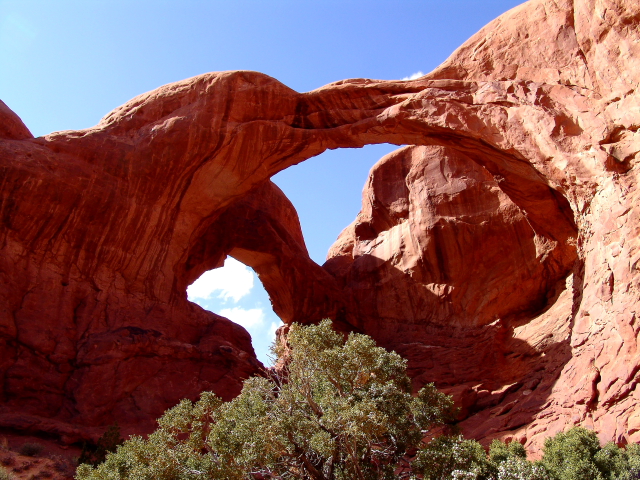
Double Arch is the tallest arch (112 feet) and second-longest arch (144 feet) in the Park. The arch is unusual in that two massive arches are joined at one ene.
The North Window Arch is a massive formation with steps that lead up the slope, so it is possible to stand underneath the arch.
There are many well-maintained hiking trails that meander between the arches.
When I first visited Landscape Arch, there was a hiking trail that went under the arch. However, in 1991 a large part of the arch collapsed and then in 1995 there were two additional rock falls, so the Park Service closed the hiking trail. Landscape Arch is the fifth longest natural arch in the world, with a span of 290.1 feet.
Delicate Arch is a free-standing 60-foot tall and is the most widely recognized landmark in Arches National Park. A picture of the Arch appears on Utah License plates. In preparation for the 2002 Winter Olympics in Salt Lake City, the Olympic Torch Relay passed through the arch. The dark color on the inside of the arch is a result of a photographer who built a large fire under the arch so that he could demonstrate a nighttime photo technique to a group of amateur photographers. In addition to being kicked out of the park and put on probation, the photographer was fined $10,900 to help cleanup up the mess.
Friday, April 13, 2018
RonnieAdventure #0303 - Mexican Hat, Valley of the Gods, Gooseneck, Natural Bridges National Monument, Utah
Mexican Hat (population 31) is located adjacent to the San Juan River in southeast Utah on the northern edge of the Navajo Nation. The name "Mexican Hat" comes from a near-by sombrero-shaped balanced rock that measures 60-by-12 feet.
A short distance to the north on highway U.S. 163 is Valley of the Gods scenic loop. The rock formations in this area are very similar to many formations in Monument Valley. However, this area is managed by the US Bureau of Land Management (BLM), so there are no entrance fees.
The 17-mile dirt loop trail that winds around the formations is passable in a passenger vehicle during dry weather, but a high-clearance four-wheel-drive vehicle is recommended because of the sand and rocks.
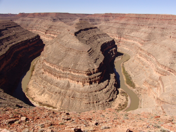
The Gooseneck Overlook is in this same area and provides a nice view of the San Juan River as it winds its way through the deep canyons. One of my "Bucket List" items is to float down the San Juan.
Natural Bridges National Monument contains a number of natural bridges, one of which is the thirteenth largest natural bridge in the world. There are also a number of Indian ruins in the canyons.
"Natural bridges" are different than "arches" because bridges are formed by water erosion flowing under a rock layer to form a "bridge.".Therefore, "bridges" typically span a canyon, while "arches" are formed by wind and weather erosion and can occur anywhere.
In 1904, the National Geographic Magazine publicized pictures of the bridges that were seen by President Theodore Roosevelt. He was so impressed with the pictures in 1908 President Roosevelt created Natural Bridges National Monument, which was Utah's first National Monument. Because there were no roads in the area, and access to the monument was only by horseback, very few people visited the monument until the 1950s when dirt roads were constructed in the area for mining purposes. Utah State Route 95 that leads to the bridges was not paved until 1976.
Due to its remote location, the Monument has the only National Park Service night sky monitoring station in the United States. The night sky rates a Class 2 on the Bortle Dark-Sky scale.
Mule Canyon Ruins (GPS Coordinates: 37 32 21.50, -109 44 31.12) are located on BLM Land and are reached from Utah State Route 95 about 20 miles southwest of Blanding. (Ruins are not listed on most maps.)
Close to the highway there is a nice interpretive site that includes a kiva and other ruins. From the parking lot there is a hiking trail to the canyon's rim and various cliff dwellings are visible across the canyon. However, to visit Flaming House Ruins (House of Fire) requires hiking up the canyon from a trail that starts from Arch Canyon Road to the east of Mule Canyon Ruins. Unfortunately, we did not have time to make the hike; but I have seen many beautiful pictures of the ruins.
Saturday, April 7, 2018
RonnieAdventure #0302 - Monument Valley Navajo Tribal Park - Arizona
Almost every article about Monument Valley Navajo Tribal Park starts with a picture of the same two formations, so why break tradition. Unfortunately, we arrived late in the afternoon with only a little light left to take a few pictures and the nearest available hotel room was in Mexican Hat, Utah. (Pictures are from a trip taken several years ago.)
Monument Valley (Tse Bil' Ndzisgaii, meaning Valley of the Rocks in Navajo) is a collection of large sandstone buttes on the Navajo Nation Reservation that have been featured in many Western movies. Some of the buttes are about 1,000 feet tall.
To many people, they often think of Monument Valley when they think of the American West. The Navajo like to say that the Park looks today like it did 30 years ago, which is what it looked like 300 years ago, which is what it looked like 3,000 years ago. In other words, there is not a lot of change in the Park.
The vivid red color in the buttes comes from iron oxide and the darker blue-gray rocks get their color from manganese oxide. There are also mineable deposits of uranium, vanadium and copper in the soils.
An access fee is charged to drive the 17-mile dirt loop road in your private vehicle, but other parts of the Park are accessible only by guided tour. Tourist literature states that Monument Valley is "Big Rocks, Big Sky, and...nope. That's it."
Subscribe to:
Posts (Atom)