Friday, July 19, 2013

RonnieAdventure #0059 - Days 36-42, Las Vegas-Alaska-Las Vegas 2013 Trip

Week 6

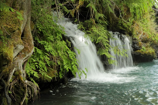
Day 36 - Haines (Alaska) is a bird-watchers paradise with over 260 species of birds found in the area; however, most people come to Haines to view the bald eagles. In the autumn months there are about 3,500 eagles in the Chilkat Valley, making it the largest gathering of bald eagles in the world.

The Bald Eagle Foundation: Natural History Museum is located in Haines and gives tours of the facility and eagle demonstrations several times a day during the summer months. We were not there at the right time to see an eagle demonstration; however, one of the trainers had an owl on display that we could photograph.


The price of an admission ticket to the Natural History Museum also included the Sheldon Museum, where First Nations people were demonstrating how to carve a totem pole.


The most impressive museum in Hines; however, is the Hammer Museum. The museum contains over 8,700 different hammers and is the largest hammer museum in the world! Included in the extensive display of hammers, is a hammer that was use in the construction of the Giza  pyramids. The owner of the museum is considered to be one of the world's leading experts in hammers and from time-to-time the Smithsonian Institute has used him to identify some hammers in their collection. You could spend all day in this museum! (But, we didn't!)


Before leaving town we had a self-guided tour of the Haines Packing Company where we watched the workers process crabs. We were told that the crabs were being prepared for shipment to the USA.


Leaving Haines we traveled the Haines Road to Haines Junction, which is one of the most scenic roads that we have traveled on this trip. The road starts at the ocean port of Haines and then crosses the highest mountains in Canada. Before reaching Haines Junction, the road climbs above the treeline and provides spectacular views of the surrounding peaks. This is one of the "roads less traveled," as we encountered very few vehicle between Haines and Haines Junction (152 miles).

As an added bonus, we saw two Trumpeter Swans nesting on one of the high-mountain lakes. When I was asked how I knew that they were Trumpeter Swans, I explained that I had been keeping track of wildlife that we had seen on the trip, and since I hadn't checked "Trumpeter Swan" off of the list, I made a positive identification that they were Trumpeter Swans.

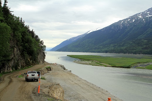
The Haines Road was built by the US Army Engineers during WWII to help provide supplies for construction of the Alaska Highway. Then, after the War, the road was donated to Canada. (Canada purchased the Alaska Highway and opened it to the public in 1948.) It would be easy to spend a week camping along this road.


At Haines Junction, we finally went to bed at 11:30 PM (see picture below), but the sun was still shinning!


Day 37 - Burwash Landing, Beaver Creek, Tetlin Junction (USA), Tok

At Burwash Landing I found the technically correct largest gold pan in the World!


Day 38 - "Top of the World Highway" from Tok to Dawson City, with  a stop in Chicken.

Everyone should experience Chicken, Alaska, at least once in their lifetime. According to the locals, when the town was established it was to be called "Ptarmigan", but no one knew how to spell "Ptarmigan", so they settled on Chicken.

 
Chicken is reached by a narrow, dirt road that is in fair-poor condition and the road is closed quite often. A stop at the one-room log cabin post office is a must, where you can have your picture taken in front of the building holding a rubber chicken.


Actually, there are all types of chickens scattered around the little community. They even have some penned up "Attack Chickens!" Well, at least that is what the sign says.


In the restaurant you can not order a chicken sandwich - all that is available is "that other bird." At the saloon, you can leave your hat/cap nailed to the ceiling or walls, but unfortunately I forgot to bring an extra hat/cap.


Later in the evening we arrived in Dawson and managed to catch the ferry across the river without any problems. However, we soon discovered that Dawson was a major bottleneck and campers were backed up everywhere. Unfortunately, when we arrived at the campground we found that they had given our camping reservation away, but they did finally find us a space for one night.

It had been raining for several days and many travelers did not want to attempt the muddy, dirt road from Chicken to Tok until the road dried out. We made it without using 4WD, but there were places that we did some slipping and sliding.

Also, the Dempster Highway was completely closed because it was washed out due to rains and heavy snow runoff from the mountains. There were no projected dates for reopening the road. We were disappointed that the Dempster was closed because we had really wanted to drive up to the Artic Circle (along with most of the other travelers that were stuck in Dawson).

Apparently, the Dawson area typically gets about 5 feet of snow, but last winter they got 15 feet. This was typical of everywhere that we went in Western Canada on this trip and most of the rivers and streams were in a flood stage, so we didn't do a lot of water activities.

In the evening we went to Diamond Tooth Gerties Gambling Hall and Saloon to see a stage show, which was just excellent. The entertainers were really professional!


Day 39 - Moose Creek, Stewart Crossing, Pelly Crossing, Carmacks, Whitehorse

We were really thankful that we were headed toward Whitehorse because the ferry line to cross the Klondike River stretched almost all the way back to the middle of town. Since the ferry only holds about two RV at one time, I'm certain that some people spent most of the day in line.

Before leaving the area we visited the Dredge No. 4, which was the largest dredge in the world ever constructed (it is 10 stories tall and built in 1912). We had a great tour guide and he was really able to explain how the dredge worked.


We also toured the Dawson City Museum, which has a lot of period artifacts.


The road from Dawson to Whitehorse is fairly remote, so we had to watch for every gas station that was open. Fortunately, just when we were really getting low on gas, we found an open station. We have learned that you don't ever want to pass an open gas station on these highways, since many remote gas stations are not always open.

Day 40 - Whitehorse is a great place to spend a few days and catch up on doing the laundry, cleaning the vehicles, etc. So far, we have washed the truck and trailer three times!

As you enter the town of Whitehorse, there is a large statue of a horse in front of the City Utility Building that is made entirely of used or broken utility parts. Much to our surprise, we found out that the town's name does not come from a "white horse," but the town derived its name from whitecaps on the river rapids that resemble horses' heads with white flowing manes.
 
 
Although the "white horse" statue is impressive, the most impressive and well known item in Whitehorse is the airport weather vane -- an actual DC-3 airplane mounted on a pedestal and it is so well balanced that a wind of less than 5 km/h can move the plane's direction!

 
Between errands we also visited a mammoth museum, an old paddlewheel steamboat (the S.S. Klondike), and a historic church. The mammoth museum was really well done and they also had a series of very informative movies to watch. We also attended the Fantastic Follies review in the evening.


Day 41 - We spent the morning at the MacBride Museum of Yukon History, where I panned for gold. I didn't strike it rich, but I did find a few gold flakes.


After lunch we went to the old railroad museum to ride the train, only to find that a private party had rented the entire facility for a wedding; thus, everyone went shopping for the rest of the day and I took a nap!


Day 42 - Johnson's Corner, Teslin, Swift River, Watson Lake

As we were laving Whitehorse, we noted some old WW11 construction equipment that was partially hidden in the trees by the side of the road. Apparently, the equipment had been used in the construction of the Alaska Highway. We were surprised that the equipment had not been moved to a museum.

 
While enroute to Watson Lake, we stopped by the Tlingit Heritage Center and watched a movie about the First Nations people in the area.


Saturday, July 13, 2013

RonnieAdventure #0059 - Days 29-35, Las Vegas-Alaska-Las Vegas 2013 Trip

 
WEEK 5

DAY 29. – The North Pacific Cannery in Port Edwards was established in 1889 and ran almost continuously for 100 years. Today, it is the most complete remaining salmon cannery from the 1800’ in the world. Most of the equipment is still in operating condition and they provide a working demonstration during the cannery tour.

The cannery was established at this location because the bay is the third deepest, ice-free, natural harbor in the world and it is closer to Asia than any other Canadian or Continental U.S. port.


Later in the afternoon we traveled back to Terrace and camped for the night before starting north again. The scenery along the way was spectacular!


Since the sun doesn’t even start to set until about 11 PM, we decide to drive up to Nisga’a Memorial Lava Bed Provincial Park and Beaupre Falls. At the lava beds I was surprised to see the lava almost completely covered with moss and it was interesting to watch the salmon "jump" up the falls. 


DAY 30 – Kitwanga, Gitanyow, Stewart, Hyder

This part of BC, with its high snow-capped mountains and rushing streams and rivers, is really beautiful. On the drive into Stewart the road passes very close to Bear Glacier, which is unusual because the glaciers are typically located high in the mountains where there are no roads.

After leaving our trailer at a campground in Stewart (British Columbia), we drove over to Hyder (Alaska) and then up to the Salmon Glacier summit viewpoint. Hyder has really fallen on hard times in recent years and most of the retail stores have closed. Hyder now considers itself to be a ghost town!


Bear Glacier
 
Rush Hour Traffic in Stewart (British Columbia) 

Sign in Hyder (Alaska)


Road to Salmon Glacier
 

Salmon Glacier 
 
Salmon Glacier

DAY 31 – Iskut, Dease Lake, Jade City, Centreille, Good Hope Lake, Watson Lake.

The world’s largest toaster museum is located in Stewart, and they also serve food; so we started the day with breakfast in the toaster museum. If you are interested in toasters, you don’t want to miss this museum. I didn’t realize that there were so many devices invented to burn bread!


We had been warned that the Cassiar Highway going north was in “bad condition,” but I didn’t realize how bad, “bad” can be. This is the first time that I can ever remember using 4WD to get through a construction zone. Now I know what they mean when they say that there are only two seasons in BC – Winter and Construction! However, we had beautiful scenery for the drive!


By the time we reached Watson Lake, I had unfortunately ruined one of my new tires (fortunately I had three spare trailer tires along), broken the TV in the trailer when it came loose and landed on the floor, the cupboards had been rearranged, and the trailer floor was littered with everything that should have been on a shelf or on one of the beds.


While in Watson Lake, we watched a program on the Northern Lights at the Northern Lights Center, toured the airport facilities that had been a WW II base, and visited the Sign Post Forest. The "forest" is now composed of over 76,000 signs from around the world, and we failed to bring a sign along!


Day 32 – Swift River, Teslin, Johnsons Crossing, Jake’s Corner, Taglish, Carcross, and Skagway (Alaska).

 After finding a campground we walked around Skagway and looked at the historic buildings. The U.S. National Park Service now occupies the old driftwood building, which has a frontal facade made entirely of  driftwood. We even found a giant 106 year-old rhubarb plant when we were walking around the town!


DAY 33 – In the morning we hiked up to Reid Falls and toured the Gold Rush Cemetery where all of the famous and notorious people of Skagway are buried. One man even has a large gold nugget attached to his grave, since he couldn’t take it with him.


Lunch was at the world famous Red Onion Saloon and Brothel Museum. At one time the Red Onion was considered to be the most exclusive bordello in Skagway.

 
After lunch we attended “The days of ’98 Show,” which is the longest running show in the North. (It started in 1923.) Since we were sitting in the front row, we even got to participate in the show.
 

After the show, we went with a National Park Service Ranger on a guided tour of the old Dyea town-site. (About 8 miles from Skagway on a narrow, dirt trail.) Very little is left of the original buildings and the land disturbance is quickly being reclaimed by Mother Nature. The open fields were blanketed with wild Irises; and, as it turns out, there are more different types of moss found in this area than anywhere else in the world!


Although we didn’t ride the White Pass & Yukon narrow gauge train this time, we did ride it on our last trip; so I’m including some pictures that were taken from the train. This train one of the last remaining narrow gauge railroads still offering passenger service in North America. The views are breathtaking as the train hangs on the side of sheer cliffs, passes waterfalls, goes through tunnels, and travels over high trestles. A train trip that should be on everyone’s bucket list!


Day 34 – We decided that for a change of pace we would book passage on the ferry from Skagway to Haines. The ferry ride was relaxing, the scenery was great, and it really beats driving the Alaska roads! Plus, it saved about 375 miles of driving.

Skagway Harbor


Haines Harbor
 
DAY 35 – You realize how small the world is when you run into old friends from Hawaii now living in Haines, Alaska!
 
After lunch we drove out to Chilkoot Lake to see the bears, but apparently the bears didn't get the message because they didn't show up. We did, however, see some really beautiful scenery and we watched the fishery people catch and tag fish. Also, along the road were some artistic rock sculptures that were quite unique.


Catching and Tagging Fish


Historic Fort Seward was closed and sold after WWII, but the buildings are now being refurbished and sold for housing, bed & breakfast rooms, restaurants, and museums.


Although we didn't go to Tracy Arm Fjord, Juneau, Glacier Bay, and Ketchikan, on this trip; I am including some pictures from our last trip when we did visit these places.
 
Tracy Arm Fjord


Mendenhall Glacier
 
 
Glacier Gardens in Juneau


Glacier Bay


Ketchikan