Thursday, August 29, 2013

RonnieAdventure #0063 - Calico Early Man Site, San Bernardino County, California

There is probably not an archeological site anywhere in the world that is more controversial than The Calico Early Man Site, located about 15 miles east of Barstow, California.

For years people had found rocks in the Calico Hills that appeared to have been chipped into ancient scrapers, but most archeologist were not interested in looking at the site. Then, in 1959 a California archeologist traveled to the British Museum of Natural History in London for a meeting and while she was there she showed the scraper samples to Dr. Louis Leakey. Leakey had been convinced that the number and distribution of native languages in the Americas required more than 12,000 years to evolve, but most archeologist rejected his theory and he had no evidence to prove otherwise.

After seeing the scrapers, Leakey decided that the Calico Hills site may be the place to find evidence that would prove there was a human presence in the Americas for more than 12,000 years. Leakey visited the site and discovered that the Calico Hills where the scrapers were found had been located on the shoreline of a freshwater Pleistocene lake that emptied (probably catastrophically) approximately 18,000 years ago. Preliminary data suggested that before the lake emptied there would have been rich vegetation in the area to support a human population.

In 1963 Leakey obtained research funds from the National Geographic Society to excavate a site in Calico Hills. The level of excavation at the site varied with time; but Leakey continued to be involved in the project until his death in 1972, at which time the site was taken over by the U.S. Bureau of Land Management (BLM). Over the years, thousands of rocks that bear a strong resemblance to prehistoric tools have been found at the site, but no other evidence of human activity has ever been discovered.

Then, in 1973, geologist Vance Haynes made three visits to the site and decided that the "artifacts" were not scrapers, but were just naturally formed geofacts. According to Haynes, the geofacts were formed by stones becoming fractured in an ancient river that was once on the site and the fractured stones just resemble scrapers. Other papers have been published that agree with Haynes, but there are also archeologists that disagree with the Haynes findings.

The debate continues today on whether the fractured rocks found at the site are "tools" or "geofacts." The site is now open to the public and various guided and self-guided walking tours are offered. The Rock Wren Pit is still being excavated and the public is invited to participate in site excavations the first full weekend of each month. Who knows, maybe you could be the person that discovers the first evidence of human activity at the site!


Sunday, August 25, 2013

RonnieAdventure #0062 - Desert Discovery Center, Barstow, San Bernardino County, California

When I learned that the second largest meteorite ever discovered in the United States was on display at the Desert Discovery Center in Barstow, California, I knew it was time for a RonnieAdventure!

The Desert Discovery Center is comprised of a unique partnership between the Bureau of Land Management (BLM), National Park Service (NPS), Barstow Community College, City of Barstow, and several other organizations, with a mission to "develop and implement a comprehensive formal and informal education center with programs focusing on the natural, cultural, and historic resources associate with the California Desert." Since most activity at the center is during the winter months when school in in session and there are more tourist roaming around the area, we had the place mostly to ourselves.

After I studied the Old Woman Meteorite from various angles, and engaged the right side of my brain to be more creative, I could finally see the profile of an old woman's face with a short pudgy nose and her mouth partially open. When I explained this to the a docent that worked in the center, she smiled and politely explained that the Old Woman Meteorite was actually named for the place where it was found - the Old Woman Mountains in San Bernardino County, CA. (I guess the people that named the meteorite didn't use the right side of their brains!)

Apparently, in 1975 three prospectors found the meteorite and immediately tried to file a mining claim on the site. Unfortunately, meteorites found on Federal lands fall under the Antiquities Act and are considered to be objects of national scientific interest. Therefore, the meteorite became an artifact of the Smithsonian Institution's Museum of Natural History in Washington, DC.

However, removing the meteorite from the Old Woman Mountains turned out to be a difficult task because of the rugged topography and the desert's summer heat. It finally required the U.S. Marine Corps to complete the job!

The First Marine Division Support Group climbed up to the site, and by using equipment lowered from a helicopter, they managed to get a double thickness of cargo netting around the meteorite. Then, a helicopter from the Marine Heavy Helicopter Squadron 363 moved the meteorite to a road where it could be transported back to Barstow.

At the Smithsonian Institute, the meteorite was found to weigh 6, 070 pounds when delivered, but a section of the meteorite weighing 942 pounds was removed and examined to determine the chemical makeup.

The meteorite was found to be quite rare and composed mostly of iron, about 6% nickel, and small amounts of cobalt, phosphorus, and chromium. It is believed that the meteorite came from the Asteroid Belt located in an orbit around the Sun between Mars and Jupiter and is probably a fragment produced from the collision of asteroids.

In addition to the Old Woman Meteorite, there are various other types of meteorites on display. Apparently, about 92% of the meteorites falling to Earth are a compose of stony material, about 6% are composed of iron-nickel, and about 2% are stony-iron composites. The iron-nickel meteorites are typically the only ones found because the other 94% all resemble rocks on the ground.

In 1980 the Old Woman Meteorite was returned to Barstow where it is to be kept on permanent display at the Desert Discovery Center. The public is invited to stop by the Center to view the Meteorite.


Sunday, August 18, 2013

RonnieAdventure #0061 - Nevada State Museum, Las Vegas Clark County, Nevada

I had planned to have a RonnieAdventure in Arizona this week; but when I turned on the TV and the weatherman said that it was going to be 111 degrees with 95% humidity, I decided that an indoor activity may be more appropriate. The Nevada State Museum seemed like a great choice because I had never been to the new museum building and I also had two free passes.

The museum contains a variety of fossils that range from a Mammoth to an Ichthyosaur, the latter being the Nevada State Fossil. There is also a nice display of First American artifacts and a tribute to early pioneers that settled Nevada.

A portion of the museum is also reserved for temporary exhibits, which is currently featuring Family Flowers, traditional embroidery from southern Mexico by Romeo Siguenza Hidalgo. The exhibit tells a story of how traditional arts are maintained and passed down in families from one generation to the next. On display are numerous dresses and other finely embroidered articles, including a huipil (worn as a blouse or tunic) that Romeo made for his daughter. The huipil is worn for protection and, according to a legend, the person who puts it on will wear a garment that is almost magical. The birds on the chest and back are to protect the woman, her spirit, and her soul. The exhibit goes on to say that "the flower is life, and life is strength and power. Our people believe that through flowers you receive the sun's energy. The flower takes it from the sun and the person takes it from the flower."


Sunday, August 11, 2013

RonnieAdventure #0060 - Calico Tanks, Red Rock Canyon National Conservation Area, Clark County, Nevada

After Alaska, it is hard to get accustomed to the Las Vegas heat; so I had to get up early in the morning for a RonnieAdventure!

Although hiking in Red Rock Canyon NCA is not ideal in the summer months, the hike to Calico Tanks is not too bad because the trail is on the west side of the mountain and shaded most of the morning.

The trail starts at the old sandstone quarry, where at the turn of the century large sandstone blocks were cut and shipped to Las Angeles and San Francisco for decorative building facades. The sandstone was of high quality, but production and shipping was expensive; thus, the company went out of business in 1906. The quarry was briefly reopened a few years later, but closed forever in 1912. Some of the large blocks are still randomly stacked around the area, waiting for shipment.


A short distance up the trail is an Agave roasting  pit, which was a seasonal cooking pit used by the Southern Paiute, Mojave and possibly Anasazi cultural groups. Agave was an important food source to the Native Americans because it could be eaten soon after roasting or it could be pounded into sheets and dried for later use. It is said to taste much like steamed asparagus. A number of similar roasting pits can be found throughout Red Rock Canyon. 


The trail to Calico Tanks winds up a beautiful canyon, which has many interesting rock formations that vary in color from gray to red. Although it is somewhat hard to follow the trail, and some rock scrambling is often required, if you just keep going up the canyon you will eventually arrive at Calico Tanks. 

I have been to the Tanks many times, but this is the first time that I have ever been there when the Tanks were dry. Without water, some of the allure is missing, so I have attached some additional pictures that were taken on other trips at different times of the year.


Historic file pictures taken at various times of the year.


Sunday, August 4, 2013

RonnieAdventures #0059 - Days 50-52, Las Vegas-Alaska-Las Vegas 2013 Trip

Week 8

Day 50 - Shelby (Montana), Great Falls, Helena, Boulder, Whitehall, Silver Star, Twin Bridges, Sheridan (wrong turn), Twin Bridges, Dillon, Idaho Falls (Idaho), Pocatello

A planned short stop in Great Falls turned out to be almost four hours, which included a trip to the "Great Falls of the Missouri River" and the Lewis and Clark Interpretive Center. The falls were a disappointment, as almost all of the water was being diverted through Ryan Dam's power turbines. Apparently, due to drought conditions, this is the lowest water flow over the falls in years.


The Lewis and Clark Interpretive Center was exceptionally well done and we could have spent additional time looking at the exhibits and watching the various movies available. According to the displays, it required 30 days and 18 miles to portage around all of the falls.
 
 
On the way to Helena we stopped by "Beaverhead Rock," which was a major turning point in the Lewis and Clark Corps of Discovery. The Corps was desperate for horses and supplies so that they could make it over the Rocky Mountains before winter, when Sacagawea recognized Beaverhead Rock where her people spent the summer months. Sacagawea was from the Lemhi Shoshone Tribe and had been taken captive as a child; thus, she was anxious to be reunited with her people that she had not seen in several years. Fortunately, her brother was now the Tribe's Chief, so he gave the Corps horses, provisions, and even supplied a guide to get them safely over the Rockies.


Day 51 Pocatello (Idaho), Ogden (Utah), Salt Lake City, Highland

At Highland (Utah) we watched young acrobats training for the Olympics, or maybe Cirque du Soleil, and even parked our trailer at their training camp for a night.


Day 52 - Interstate 15 to Las Vegas (Nevada)

Arriving in Las Vegas after 52 days and 10,080 miles, home never looked so good.


Things are now getting back to normal, although it required a lot of hard work to get all of the bugs and road tar off of the truck and trailer. (You would never know it, but I washed the truck four time while on the trip and the trailer was washed twice.) After dropping a 20 pound iron bar on my foot, my toes went from pink-to-purple, but the swelling has now decreased and the toes are returning to their normal color, even though I'll probably loose the nail on my big toe. We had the dime-size rock chip to the front windshield of the truck drilled out and repaired. After smashing my watch on a rock the first week, it continued to work for the entire trip and then quit the day after we got home. Next week I'm going to see if I can repair the TV that was damaged when it fell off of the shelf on the rough roads. Then, we will be ready for another RonnieAdventure!


Trip Statistics and Cost Summary:
Total Miles - 10,082
Average Miles/gallon - 10.05
Average Cost/Day - $225
Cost breakdown by Percent:
     Gas - 46%
     Camping Fees - 15%
     Eat Out - 12%
     Tours/Attractions - 11%
     Food from Store - 5%
     Souvenirs - 4%
     Supplies - 2%
     Miscellaneous - 4%

Sunday, July 28, 2013

RonnieAdventure #0059 - Days 43-49, Las Vegas-Alaska-Las Vegas 2013 Trip

Week 7

Day 43 - Coal River, Liard River, Muncho Lake, Toad River, Fort Nelson

Not too far from Watson Lake we came to Historic Milepost 496, which is the turnoff for Liard River Hotsprings Provincial Park. A short walk down a boardwalk leads to the pools; however the day we were there only one pool was open. The boardwalk was constructed because the trail to the springs crosses a wetlands that supports over 250 boreal forest plants, including 14 orchid species.


About 20 miles down the road we came to the only remaining suspension bridge on the Alaska Highway. The 1,143-foot suspension bridge was constructed in 1943 to replace a temporary structure that had originally been installed in 1942.

 
On this part of the trip we saw more wildlife along the road than anywhere else on the trip - bears, moose, caribou, deer, and elk. The caribou looked like someone had run over her with a truck!


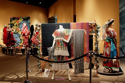
At Toad River we found another collection of caps - 8,314 to be exact.
 
 
We arrived in Fort Nelson too late to tour the Heritage Museum; but since our campground was adjacent to the Museum property, after dinner I walked around and photographed some of the Museum's exterior exhibits.


Day 44 - Prophet River, Slkanni Chief, Pink Mountain, Wonowon, Charlie Lake, Fort St. John, Taylor, and Dawson Creek.
 
It is amazing how much the Alaska Highway has changed since its original construction and how much it is the same. At Historic Mile Post 148 we came to "Suicide Hill," where there had been a sign with an ominous greeting: "Prepare to Meet Thy Maker." With four-wheel disc brakes on the pickup, I only downshifted from 5th to 4th gear at the top of the hill. However, the road is probably in the same, or maybe worse, condition as when it was first constructed.
 
At Mayer we saw the largest golf ball in the world.
 
 
For people that want to say that they drove the original Alaska Highway, about 17 miles form Dawson Creek a section of the original highway has been preserved and is now used as an access road to Kiskatinaw Provincial Park. Another reason to take the side trip is that the road crosses the Historic Kiskatinaw River Bridge, a 531-foot long structure that is the only remaining original timber bridge built along the Alaska Highway that is still in use today.
 
 
Also in this area are a number of fields that contain bright yellow flowers. We were told that the plants are Canola, a hybrid of Rapeseed, which was developed as a low-cholesterol oil seed. The raw seeds are processed in Alberta and some of the seeds are shipped to Japan for processing.
 
  
Dawson Creek is Mile "0" for the Alaska Highway, so everyone has to stop and take a picture of the sign and official mile marker. Also in the same parking lot is the Historic Dawson Creek Grain Elevator that has now been converted into an art gallery. A spiral staircase has been installed on the inside of the elevator, so you just wind your way up to look at the exhibits.


Day 45 - Pouce Coupe, Demmitt, Hythe, Beaverelodge, Wembley, Gande Prairie, Bezanson, Debolt, Crooked Creek, Calais, Valleyview, Little Smoky, Fox Creek, Whitecourt, Mayerthorpe, Sangudo, Onoway, Spruce Grove, and Edmonton
 
There is a beautiful Visitor Centre in Grande Prairie that contains a museum and a large selection of tourist information. The staff was very helpful!
 
 
About 75 miles from Edmonton the road crosses under the second largest wooden railway trestle in the world. The C.N.R. Rochfort Bridge Trestle was constructed in 1914 and is 2,414 feet long.
 
 
Day 46 - Around Edmonton
 
We spent the morning at the Muttart Conservatory, one of Edmonton's most iconic structures, consisting of four glass pyramids. Each pyramid contains a different eco-system.


After lunch we toured the Royal Alberta Museum, which contains ancient artifacts, displays of minerals, animals, birds, bugs and every insect species known in Canada and other parts of the world. You run out of energy before you run out of museum! We have discovered that when you see the world "Royal" in the name of an attraction, it is a place that you don't want to miss. Apparently the Queen only approves a very limited number of attractions, and she has to approve the attraction before they can use the word "Royal" in the name.
 
 
In the evening we went to the West Edmonton Mall for dinner, which is the largest mall in the world. Enclosed in the mall is everything from a marine sanctuary to a swimming beach and ice arena.


Day 47 - Still in Edmonton
 
Everyone told us that we couldn't leave Edmonton without visiting Fort Edmonton Park and K-Days. Fort Edmonton Park is the largest living history museum in Canada with original and rebuilt historical buildings representing the past 100-150 years of history in the area. 


K-Days (Klondike Days) is similar to a state fair in the US, with lots of carnival rides, exhibits, and free live stage performances. We went to the Mana show (a production similar to Cirque du Soleil), which was just excellent.


Day 48 - Devon, Leduc, Kavanagh, Millet, Wetaskiwin, Gwyhne, Bittern Lake, Camrose, Meeting Creek, Stettler, Drumheller, Hwy 9 to Hwy 21 to Hwy 1, Chestermere.
 
Shortly after leaving Edmonton we noticed a sign advertising the Leduce #1 Energy Discovery Center, so we turned around (not an easy task when pulling a trailer) and went back for a tour. It was an amazing place with lots of exhibits. We even got to sit inside of the largest drill bit in the world as it bored a mile down into the earth. You could look down and watch the drill grinding through the rock layers and then you could look up to see the material going up the shaft. And, of course, you could observe the different rock layers as you were descending through the earth's crust. Okay, so it was just a simulation, but it was interesting.


Next stop was the Reynolds Alberta Museum, which celebrates the Spirit of the Machine and contains a wide variety of vehicles, airplanes, tractors, and industrial equipment. This international award-winning museum of mechanization features Canada's Finest and largest collection of rare and unusual one-of-a-kind items, including a 1929 Duisenberg Model J. 


Even though it was late in the day, we stopped by the Royal Tyrrell Museum, which features an amazing collection and display of dinosaurs. The museum is so popular that it stays open until 9 PM at night during the summer months. Too little time - too many museums! 


Day 49 - Cheadle, Carseland, Mossleigh, Vulcan, Kirkcaldy, Champion, Carmangay, Barons, Nobleford, Picture Butte, Coaldale, Hwy 4 to Coutts and U.S. Boarder, Sweetgrass (US), Sunburst, Shelby.
 
Since we were in the area, a stop in Vulcan was a must. Unfortunately, we were too early to visit the new museum was is scheduled to open August 2, 2013. However, we toured the old visitor's center that is designed to look like a space station and looked at the exhibits on display. There is a Starship statue (Not the Enterprise, but a similar design.) on display as you enter the city, which contains greetings in several languages.