Sunday, May 17, 2015

RonnieAdventure #0152 - Washington County, Utah - 2015 Part III

Traveling north from St. George on State Route 18 we came to Diamond Valley, which is becoming a bedroom community for St. George. There is not much commercial activity in Diamond Valley, but we did find some interesting "lawn art" and flowering trees.


Veyo is located at the base of a dormant volcano cone and is well known for its bakery that sells pie by the slice. Since we were on a diet, we just ate one slice and ordered one slice to go.


A few miles up the road from Veyo is Baker Dam Campground and reservoir. There is a beautiful little stream at the base of the dam and an abundance of wildlife around the reservoir. 


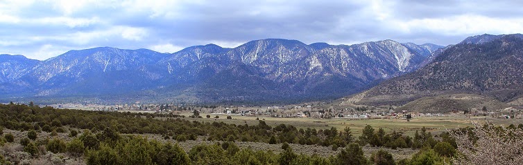
Pine Valley is located in Dixie National Forest at an altitude of over 6,500 feet; thus, the mountains were still covered with snow and it was coooold!  


The historic Pine Valley Ward Chapel was designed by shipbuilder Ebenezer Bryce in 1868 in the shape of an upside-down ship. The Chapel is the oldest LDS Chapel in the world in continuous use. Just down the street from the Chapel is the Pine Valley Heritage Center, but it is only open during the summer months. 


Adjacent to the Pine Valley Reservoir is a campground that is specifically designed for campers with horses. Each campsite contains a separate corral and a hitching post. However, the only campers we encountered were a herd of deer. 


Just off State Route 18 South of Enterprise is the Mountain Meadows Massacre site. There are a number of monuments around the area, but the main memorial is on a hill overlooking the meadows and a large rock monument is located in the meadow where the pioneers were camped. 


Friday, May 8, 2015

RonnieAdventure #0151 - Washington County, Utah - 2015 Part II

St George is the largest city is southeast Utah with a population of about 80,000 residents and it is the second fastest growing metropolitan area in the United States. 

The City was originally settled by Mormon Pioneers in 1861 and the St. George Utah Temple of the Church of Jesus Christ of Latter Day Saints was completed in 1877. The LDS Church has over 140 Temples world-wide, but the St. George temple is the longest continually operating temple. There are no tours of the Temple, but there is a visitors center adjacent to the Temple that is open and free to the public. 


Located in the Historic Section of St. George is the old Court House and the Pioneer Museum that is operated by the Daughters of Utah Pioneers. Both are open and free to the public.


The Historic Section of St. George contains a number of well-kept historic houses, but one of the most interesting is the Brigham Young Home. Free tours are offered throughout the day. There is a large tree in the back yard, but I do not remember what the guide told us about the tree. I think she said that it was on some type of register of historic trees. Anyway, the tree split in half a number of years ago and is now held together with cables.


Snow Canyon State Park is locate west of St. George in the Red Mountains. This is a high tourist destination, so camping reservations are required well in advance. 


The Canyon has a long history of human use, dating back to about AD 200. Although no dwellings have been discovered in the canyon, there are numerous signs of hunting and gathering. 

The striking geological features in the Park consist of red and white Navajo Sandstone, sand dunes, and black cinder cones, lave tubes, and lava flows. Parts of various movies have been filmed in the Park, including Butch Cassidy and the Sundance Kid, The Electric Horseman and Jeremiah Johnson. If you visit the Park, bring lots of film or a large memory card.


Hiking trail to Johnson Arch
Johnson Arch has a span of over 200 feet
 

Friday, May 1, 2015

RonnieAdventure #0150 - Washington County, Utah - 2015 Part I


Located about 15 miles southeast of St. George in the red sand dunes of Utah are the remains of old Fort Pearce. 

Between 1865 and 1873, Chief Black Hawk led the Ute Tribe in raids against the Mormon pioneers that were attempting to settle lands the Ute Tribe considered to be there homeland. To protect the settlers, the local Mormon Militia constructed a series of "forts" along major trails in central and southern Utah Territory. 

Describing the structures as "forts" is a little misleading, because the "forts" were actually about the size of guard posts. Each "fort" was 42 feet long and 22 feet wide, with small protrusions at the northwest and southeast corners of the building to act as flanking walls. There were ten vertical firing slots located along the tops of the walls. Each "fort" was staffed with four to six men, with the intent that this small group of men could hold off an attack until help arrived. 

The Fort Pearce site was selected because it is located on a high bluff overlooking a steep canon that contains one of the few spring in the area. The fort was never attacked, but it was manned until 1873, when a peace settlement was negotiated with the Ute Tribe. 

Fort Pearce is one of only three "forts" remaining that were constructed during Utah's Black Hawk War and it is listed on the National Register of Historic Places. 


Located about three miles east of Fort Pearce is the Warner Valley Dinosaur Track Site that contains an estimated 400 plus dinosaur tracks. It is not possible to know for certain which dinosaurs made the tracks, but according to the Bureau of Land Management "the larger tracks are Eubrontes while the smaller tracks are Gallator.