Friday, October 14, 2016

RonnieAdventure #0225 - Wyoming, 2016 Part III

There is a really nice City Park in Worland that contains pioneer statues, historic displays, and clean restrooms. It was worth a stop!


Just east of Worland (adjacent to US Highway 16) is the Colby Mammoth Kill Site where bones from extinct species of Mammoths, horses, camels, and bison have been excavated. The animals were killed about 11,000 years ago by humans known as the Clovis Hunters and the site is one of the largest known Clovis mammoth kill sites in North America.

The excavated site is now filled with water, but bones from the site are on display at the Washakie County Museum and Cultural Center in Worland and at the University of Wyoming Anthropological Museum in Laramie.


Photographer Unknown
US Highway 16 that runs through Ten Sleep Canyon is one of the most beautiful drives that I have been on in a long time. The canyon's name comes from the Indians that said it takes "10 sleeps" (i.e., 10 days) to reach this canyon from Fort Laramie.

Near the canyon entrance is the former 15,000 acre Girl Scout National Center West, part of which is now owned and operated by the Nature Conservancy as the Tensleep Preserver, with facilities for workshops and seminars.

At the top of the canyon, overlooking Meadowlark Lake, is a memorial dedicated to the men trapped in the Shoshone Forest Backwater Fire on August 21, 1937. Fifteen men died and 38 firefighters were injured. Wikipedia states that "More firefighters were killed in the Backwaterfire than in any other in a United States National Forest in the 103 year interval between the Great Fire of 1910 and the Yarnell Hill Fire of 2013.


Fort McKinney, just west of Buffalo, has now been converted into a Veterans Hospital.

In 1876 Fort McKinney was established near present-day Kaycee, but moved to its present location in 1878 because the original location was in direct violation of the 1851 and 1868 treaties with the Indians.

At its current location the Fort had 14 officers' quarters (known as "The Line"), barracks to house approximately 1,400 men (seven companies), a hospital, bakery, storehouses, stables, and auxiliary buildings. Today, all of the original buildings constructed at this site have been demolished, except the hospital that has been renovated and remains in use.

In 1894, the Army deeded the property to the State of Wyoming and in 1903 the facility became the Wyoming Soldiers' and Sailors' Home. Today, the facility is known as he Veterans' Home of Wyoming.


"The Line" - Photographer Unknown
At the corner of Angus and South Main Streets in Buffalo, there is a sculptures by D. Michael Thomas entitled "Living on the Edge." The sculpture depicts a small rancher that is surprised by a rider from a large cattle ranch galloping toward him.

In 1892 small ranchers were being attacked by gunmen ("The Invaders") hired by the large ranchers; so on April 11 the small ranchers banded together and laid siege to the gunmen at the TA Ranch. Fighting continued for three days before troops arrived from Fort McKiney and the gunmen surrendered. The gunmen were sent to Cheyenne for prosecution, but they were never brought to trial.


Just a few stores to the north of the sculpture is, you guessed it, a quilt shop! Since the quilt shop was closed last time we were in Buffalo, this was a "must stop," which cost me a few dollars!


The West Texas Trail Museum in Moorcroft is small, but has a great collection of prairie history and tells how the cattle drives came to the Moorcroft area for water and good grass.


Who would have known that the "Best Town on Earth" is located in Wyoming? This required a visit!

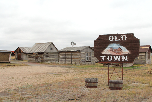
"Old Town" is located on the north side of Upton and contains a number of historic buildings that have been relocated from other areas, and some of the other buildings have been reconstructed to represent structures typical of the period.



Located on the south side of town is an interesting "pipe-man" that welcomes guest to Upton.


The Red Onion Museum in Upton received its name from the Red Onion Saloon that closed during prohibition. For a number of years the saloon artifacts were stored in a barn, then in 1996 the items were donated to the Weston County Museum Distinct. A museum was formed in Upton and it was decided to name the museum branch after the old historic saloon.


Upton even has a mall (located in one building)!


There is an interesting weather vane at the junction of Interstate 90 and Wyoming State Route 111 -- a full-size airplane that actually turns with the wind direction.


Between 1500 and 1800 A.D., prior to the Plains Indians acquiring firearms, hunting buffalo was difficult and dangerous; so the Indians often drove buffalo off of cliffs where the injured animals could be killed easier. 

In the 1970s, during construction of Interstate Highway 90, a sinkhole was discovered that contained huge volumes of buffalo bones and assorted artifacts that were perfectly preserved and covered with discrete, precisely, date-able layers of dirt.

Archaeologist currently work at the site during the summer months of each year and the public is invited to view the archaeologist at work. During the other nine months of the year the public may view the excavation site at the bottom of the pit, but the building is closed. Less than 10% of the site has been excavated, so this will be an active archaeological site for many more years.  


Photographer Unknown


If you have ever wanted to own your own town, Aladdin (Wyoming) is for sale at the bargain price of $1.5 million. Included in the sale price are 30 acres of land, the 110 year-old general store that contains a post office and bar, a trailer park, and a four-bedroom house. 

Located about a mile down the road (not included in the sale) is the historic Aladdin Tipple. 

Coal mining started at the Aladdin Mine in 1898 and the coal produced was reported to be "a good coal which burned so hot it made the stove top rattle," but the demand for domestic coal dwindled over the years and the mine closed in the early 1940s. The mine entrance has been sealed and the tipple is all that remains at the site.


Friday, October 7, 2016

RonnieAdventure #0224 - Wyoming, 2016 Part II

While traveling across Wyoming on Interstate 80, at exit 41 we pulled into a rest stop and were surprised to find a large monument in front of the rest stop building. A plaque on the monument indicated that on Wednesday July 7, 1847, and in subsequent years, the Mormon Pioneers passed this point on their movement westward. And, just two weeks later, on July 24, 1847, the first group of Mormons reached the Salt Lake Valley.


The Oregon Trail Memorial Church just outside of Eden is an old log structure that is never locked and has been vandalized only once since its existence. 

The stained glass window at the front of the building was designed by Jessie Van Brunt, a well-known New York artist, and depicts "a wide prairie vista with a long caravan of covered wagons drawn by oxen winding from the foreground into the distance."


About four miles up the road, at the junction of US-191 and Wyoming-28, is the location of the original Big Sandy Pony Express Station and several historic markers. The pony express station was in operation from April 3, 1860 until November 20, 1861.


"Parting of the Ways" was a junction on the Oregon Trail where pioneers had to decide whether to stay on the main trail that went to Fort Bridger or to go across the Little Colorado Desert. The Desert route saved time but contained about fifty water-less miles.  

In 1956, the Historic Landmark Commission of Wyoming placed a marker at a site adjacent to Wyoming State Route 28 (located about 23 miles east of the  US-191/Wyoming-28 junction) that states "This marks a fork in the trail, right to Oregon, left to Utah and California." The only problem is that the marker is located in the wrong place on the Oregon Trail and should have been located about 9.5 miles to the west. The marker is now known as the "False Parting" and the real site is called the "True Parting." 

Located about 300 yards east of the "False Marker" is an Oregon Trail marker that states "In Memory of those who passed this way to win and hold the west." The monument was placed by the Historical Landmark Commission of Wyoming in 1950. Although covered by sagebrush, deep ruts left by wagon wheel can still be seen across the high desert plateau. 


South Pass does not look very intimidating today; but South Pass, where the pioneers had to cross the Continental Divide, is considered to be the start of the most difficult part of the journey westward.


South Pass City and the Carissa Mine constitute Wyoming's largest State Historic Site.

In 1867 substantial gold deposits were found on the northeast side of South Pass, which caused a large influx of miners, merchants, and other people into the area. The population of South Pass City reached about 3,000 people by the year 1869, making it the second largest town in Wyoming Territory. However, the gold soon played out and South Pass City became a near ghost town. Current population is listed as approximately 4 people, 3 cats, and 3 dogs.

One of the people to arrive in South Pass City in 1869 was a woman named Esther Hobart Morris. In 1870, Esther became the first woman in the United States to serve as a Justice of the Peace and at her urging, she convinced William H. Bright, a saloon owner that was also a representative to the Wyoming Territorial Constitutional Convention, to include a women's suffrage clause into the territorial constitution. When the constitution was approved, Wyoming became the first jurisdiction to grant women the right to vote, a right that was not granted to women nationally until 1920!


Atlantic City is located just down the road from South Pass City and had one of Wyoming Territory's first public schools, in addition to sawmills, blacksmith shops, typical businesses and a beer brewery. As mines in the area closes, so did most businesses in Atlantic City. Attempts were made at various times to reopen the mines, but all of the attempts also were short-lived. The population of Atlantic City is currently listed as 37.


The Sacajawea Cemetery is located just outside of Fort Washakie; and contains a statue of Sacajawea holding a sand dollar, which is significant because a sand dollar was given to Chief Washiake by Lewis and Clark and he wore the sand dollar in many historical pictures.

A plaque at the base of the statue states that Sacajawea's life "after the Expedition is controversial. Her son, Jean Baptiste was adopted and educated by Captain Clark. Her adopted son, Bazil, remained in the Northern Shoshone areas. In later years, Sacajawea returned to the Shoshone homeland to live near Bazil. Many recorded documents and statements made by descendants, officials at Fort Washakie, and by the Federal Government record her death and burial place at the Sacajawea Cemetery, Fort Washakie, Wyoming in 1884."

Another nearby sign states: "The Eastern Shoshones believe Sacajawea is buried in the Wind River Mountains west of here, and Charbonneau's second wife, Sacajawea's sister, is buried in North Dakota."

Apparently, no one really knows for certain where Sacajawea is buried.


The Fremont County Pioneer Museum in Lander contains a large collection of artifacts from "prehistory through the 1920's." Surrounding the museum is a reconstructed collection of historic buildings and an example of what a Indian village would have looked like during this same period in time. 


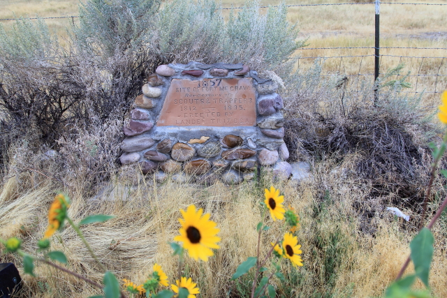
Just east of Lander (adjacent to Wyoming State Route 789) is the site of Fort Thompson, or Camp Magraw as it was called by Old Timers. 

W.M.F. Magraw was appointed superintendent by the Secretary of the Interior to construct the Fort Kearney-South Pass-Honey Lake Wagon Road from Nebraska to California; but he was later removed for mismanagement and replace by W.F. Lander, who staked a new route known as the Lander Cutoff.

A marker indicates that this was also the rendezvous site of Scouts & Trappers from 1812-to-1835.


The 1838 Rendezvous Site of fur trappers, mountain men, and traders is located along the banks of the Wind River in Riverton. The 1838 Rendezvous Association continues to hold an annual event at this site, which is "dedicated to the men, women and children who moved so lightly upon the world that only the land and the river remain as a witness to those shining times."


Hot Springs State Park in Thermopolis contains the world's largest single mineral hot spring, which pours forth about 8,000 gallons of 135 degree Fahrenheit mineral water every 24 hours. Thanks to the Shoshone and Arapaho tribes that in 1896 gave the springs to Wyoming in a treaty, with the provisions that they remain accessible to the general public without charge, there are no fees to use the facilities, including the bath house where the water is cooled to 104 degrees.

In 1896 James McLaughlin, United States Indian Inspector, reported to the Department of the Interior that "The water of this spring is said to possess wonderful curative properties and to be very beneficial for rheumatic and other ailments, and although the temperature is 132 degrees it is not unpleasant to drink, and with salt and pepper added tastes very much like fresh chicken broth."

The historic Callaghan Apartments and Hotel built in 1918 has been renovated (now the Best Western Plus Plaza Hotel) and is the only historic apartment/hotel building remaining in the park. At one time there were six facilities in the park, but the last one of the other five was demolished in 1966.

The Park is also celebrating the 100th birthday of the Swinging Bridge (i.e., suspension bridge) that was built over the Big Horn River in 1916 to provide pedestrian access to the hot springs . The suspension bridge is the longest of its type in the State of Wyoming.