
When entering the town of Ferron (2010 census population 1,626), I was greeted by an Allosaurs dinosaur, which is typical of communities in Utah's "Dinosaur Country." The town is named after Augustus Ferron, who was the government surveyor that surveyed the area as part of the Homestead Act.
Ferron has two distinguishing features - a very large Church of Jesus Christ of Latter Day Saints building and nice park that contains a veteran's memorial.


Although Molen location is shown on the Utah State Road Map, this is an unincorporated community east of Farron. Fortunately, there was a sign nailed to a telephone pole so that I knew when I had reached Molen.
Molen has a few scattered occupied houses, several abandoned structures, and a flock of peacocks that wander freely around the area. There was actually a very peaceful feeling in Molen, which was probably a function of the large tree branches that overhung the road.


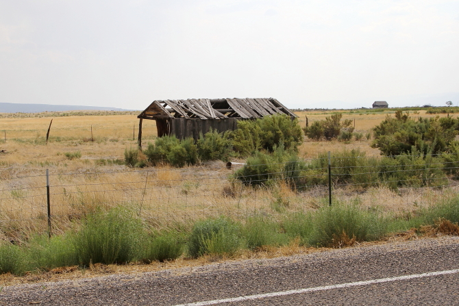
Moore (2010 census population 5) is a near ghost town with a number of structures still standing.
The community was originally named Rochester for the hometown of New Yorker M.B. Whitney, who was involved in developing the area.
Financial investors from Eastern United States saw potential for developing the lush farmland on the flats east of the Muddy River and issued shares of their investment company to other people that believed in their vision. The town soon had a store, brick schoolhouse and a post office. The community was renamed Moore after the postmaster L.C. Moore, who became the land development leader in 1907. When the Eastern investors pulled their money out of the project, most of the residents left Moore; but farming in the area continues to produce great crops.


Emery (2010 census population 288) sits at the base of the North Horn rock formation that contains numerous Cretaceous and Tertiary-ear fossil invertebrates, microfossils, and palynomorphs. Not only are there abundant dinosaur and prehistoric mammal bones found here, there are also a number of significant Fremont Indian culture archaeological sites that range from 700-1300 AD.
Early European settlers crossed the Colorado River at Moab, then crossed the Green River, and came across the Castle Valley to what is now Emery. Fur trappers and Spanish explorers had originally developed this trail and as settlers followed the same path, the route became known as "The Old Spanish Trail." Wagon ruts and other trail markers can still be seen today.
In the 1870s Mormon Pioneers arrived and started homesteading land in the area. Various LDS meeting houses were built and then in 1898 a new church was built. The 1898 building is now the oldest remaining religious building in Emery County. A sign in front of the building states "The construction technique, a wood frame sheathed with clapboard and lined with adobe bricks, is distinctive and unusual for turn-of-the-century Mormon churches. The building's Greek Revival style is reflected in the symmetrical principal façade, cornice returns, transoms, and pedimented window heads."


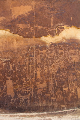
The Rochester Rock Art Panel is located east of Emery and contains a large number of petroglyphs and other artifacts. Unfortunately, portions of the site have been defaced and vandalized by relic thieves.


BONUS HISTORICAL STORIES & PICTURES
At various times when we were younger, Wileta had our family picture taken so that she could send the pictures out with her Christmas cards. I remember most times we were not very cooperative, which I now regret.


Emery (2010 census population 288) sits at the base of the North Horn rock formation that contains numerous Cretaceous and Tertiary-ear fossil invertebrates, microfossils, and palynomorphs. Not only are there abundant dinosaur and prehistoric mammal bones found here, there are also a number of significant Fremont Indian culture archaeological sites that range from 700-1300 AD.
Early European settlers crossed the Colorado River at Moab, then crossed the Green River, and came across the Castle Valley to what is now Emery. Fur trappers and Spanish explorers had originally developed this trail and as settlers followed the same path, the route became known as "The Old Spanish Trail." Wagon ruts and other trail markers can still be seen today.
In the 1870s Mormon Pioneers arrived and started homesteading land in the area. Various LDS meeting houses were built and then in 1898 a new church was built. The 1898 building is now the oldest remaining religious building in Emery County. A sign in front of the building states "The construction technique, a wood frame sheathed with clapboard and lined with adobe bricks, is distinctive and unusual for turn-of-the-century Mormon churches. The building's Greek Revival style is reflected in the symmetrical principal façade, cornice returns, transoms, and pedimented window heads."


The Rochester Rock Art Panel is located east of Emery and contains a large number of petroglyphs and other artifacts. Unfortunately, portions of the site have been defaced and vandalized by relic thieves.


BONUS HISTORICAL STORIES & PICTURES
At various times when we were younger, Wileta had our family picture taken so that she could send the pictures out with her Christmas cards. I remember most times we were not very cooperative, which I now regret.


