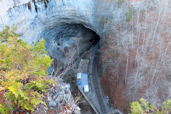
Natural Tunnel State Park in Virginia contains a natural tunnel that is 850-feet long, up to 200-feet wide, and 80-feet high. The ridgeline over the tunnel is over 300-feet high above the bottom of the canyon. Over millions of years, the tunnel was formed when groundwater bearing carbonic acid percolated through cracks in a limestone ridge and dissolved the limestone.
Daniel Boone is credited with being the first European to visit the site, but there are no official records to substantiate the claim.
The 41st U.S. Secretary of State, William Jennings Bryan, call the tunnel the "Eighth Wonder of the World." And, of course, there is the legend of the Indian maiden and a warrior from a rival tribe that fell in love and... By now readers should know the rest of the story because the same legend is told about numerous other places in the United Sates.
In 1890, the South Atlantic & Ohio Railroad laid tracks through the tunnel and it became known as the "Gateway to the Appalachian" for both freight and passenger trains. This is still an active rail line, but just for freight trains. Passenger service through the tunnel ended in 1939.
Annually, on the third Saturday of July, the tunnel is open for visitors that want to hike through the tunnel. Unfortunately, I was not there on the third Saturday of July. Also, during certain times of the year, there is a chairlift that takes visitors down to a viewing area at the bottom of the canyon. Of course, the chairlift was also not operating when I visited the park. Maybe, I will return someday during the summer months. When I was there, I just walked out to Lovers Leap and took a few picture looking down at the tunnel and railroad tracks.
In the parking lot there was a locomotive that was moved to this location from Little Stone Mountain near Norton, VA. The engine and passenger car had been used to transport tourist around the Rim Rock Railroad and Recreation Area, which contained a frontier town and other tourist attractions.
The Daniel Boone Wilderness Trail Interpretive Center located near Duffield, Virginia, is also a satellite location for Natural Tunnel State Park. The Center has a small Daniel Boone museum, but the building was not opened when we stopped for a visit.
Southwest Virginia Museum in Big Stone Gap was originally the private residence of Rufus Ayers, Virginia Attorney General from 1886 to 1890. Ayers was one of the town's developers and then in 1895 he built the house atop Poplar Hill using local limestone and sandstone. We wanted to tour the house, but they were hosting a private Christmas party that was not open to the public.
Big Stone Gap was developed as a coal-mining town in 1856. It was originally called "Mineral City" and "Three Forks," before taking the "Big Stone Gap" name, which refers to a valley on the Appalachia Straight. Because there were large coal and iron deposits in the area, the town was some times referred to as "Pittsburgh of the South."
In 1978, John Warner was in Big Stone Gap campaigning for the U.S. Senate, when his movie-star wife, Elizabeth Taylor, choked on a chicken bone when it became logged in her esophagus. She was rushed to the hospital where they were able to extract the bone and save her life. She later made a substantial donation to the hospital as a thank you.
The movie Big Stone Gap, staring Ashley Judd, Patrick Wilson, Whoopi Goldberg, and others, was filmed here in 2014.
I had made hotel reservations in Pikeville, Kentucky, so we had to keep driving after the sun set to reach our destination. As we passed through Jenkins, Kentucky, I noticed a number of signs and black monuments in front of the David A. Zegeer Coal-Railroad Museum. The markers included a variety of subjects, including: Mine Workers who lost their lives, dangerous working conditions, Black Lung Disease, United Mine Workers of America (UMWA), integration of schools and mines, and local war heroes.
I wanted to stay in Pikeville, so that I could get up early in the morning and drive up the mountain to take pictures of the Pikeville Cut-through.
In the morning, when I arrived at the observation platform, all I could see was dense fog. One of the park workers told me that if I waited until 10-or-11 AM, the fog would lift and I could get some great pictures. Unfortunately, I did not have time to wait for several hours, so I decided to leave Pikeville Cut-Through on my bucket list for a different visit.
The Pikeville Cut-through is the second largest earth-moving projects in the western hemisphere, just behind the Panama Canal. It was constructed under the direction of the U.S. Army Corps of Engineers.
Construction started in 1963 and after moving 18,000,000 cubic yards of material, the project was completed 14 years later in 1987.
The Cut-Through is 3,700 feet long, 1,300 feet wide, and 523 feet deep. Through the Cut now pass a four-lane highway, a railroad line, and the Levisa Fork of the Big Sandy River. The Levisa Fork of the Big Sandy River was relocated because each spring it typically flooded the town of Pikeville.
Hardy, Kentucky, and the surrounding area, is known as the Hatfield-McCoy Feud Historic District. Some of the family members are buried in Pikeville's Dils Cemetery, but Randolph McCoy's three sons, Tolbert, Pharmer, and Randolph Jr, who were killed by the Hatfields, are buried in the McCoy Cemetery in Hardy. There is a historic marker along the highway for the McCoy Cemetery, but we were told that the Cemetery is not open to the public. The Hatfield Family Cemetery is located in Omar, West Virginia.
Diagonally across the road from the McCoy Cemetery is the historic Randall McCoy house site. The house burned down, but visitors can still tour the site and and see the water well, as long as they obey the rules: "NO FEUDING NO FUSSING." Over the course of the Feud, it is estimated that between 12 and 20 members of the Hatfield and McCoy families were killed between 1863 and 1891.
A number of side roads can be followed around the Feud area, but the main road from Hardy leads to Preacher Anderson Hatfield's Cabin, also known as the "Hog Trial Cabin."
The Hatfield-McCoy Feud started during the Civil War days when some members of the families took different sides. However, the main feud started when "Old Ran'l" McCoy accused Floyd Hatfield of stealing one of his pigs.
The case went before Justice of the Peace "Preacher Anse Hatfield," who ruled in favor of the Hatfields, based on the testimony of Bill Staton. Staton was related to both families, but after the ruling he was killed by brothers Sam and Paris McCoy. The McCoy brothers were then acquitted on grounds of self-defense. The killings of both family members continued until 1891, when the families agreed that continuing the feud was not productive.
From the "Hog Trial Cabin," the road leads to McCarr, but we took a side trip to Blackberry to visit Hatfield-McCoy Monument located in Orville Morris Park. I could not locate the historic marker, but I was told that across the road from the Park is the site where Asa McCoy was killed.
On January 7, 1865, Asa McCoy, who was a Union soldier, was shot and killed by "Devil Anse" Hatfield, who had been a Confederate soldier. Randolph McCoy said he would never forgive the Hatfields for killing his younger brother Asa; thus, another factor in the feud.
Orville Morris Park contains a monument with the names of both Hatfields and McCoys on opposite of the obelisk. Adjacent to the obelisk is a serpentine wall that represents the Tug River that separated the Hatfield and McCoy families. The wall is located on a concrete map featuring the locations of major historic sites and information plaques located on the wall are listed by chronological dates.
Located in MaCarr is the 1882 site where the Hatfields captured Randolph McCoy's three sons and dragged them across the Tug River into West Virginia, which was outside of Kentucky law. The three McCoy brothers had stabbed and shot "Devil Anse" Hatfieid's drunk brother Ellison, so "Devil Anse" held the three boys in West Virginia until his brother died. After his brother's death, "Devil Anse" took the boys back into Kentucky, tied them to some Pawpaw bushes, and in retaliation "shot them dead" in cold blood. This killing became known as the Pawpaw Tree Incident.
The State of Kentucky issued indictments for "Devil Anse" and twenty of his supporters for the murders, but no action was taken for five years. This was considered to be the end of the first stage of the Hatfield-McCoy Feud.